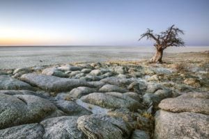
They’re vast, desolate, inhospitable, and sometimes mysterious. Most of the time they appear as glaring, white, endless plains. During the rainy season they are one of the most important wetland areas in Botswana. You can see them on the Waterfalls and Wildlife and Victoria Falls to Cape Town (gravel) trips. It’s also where TOP GEAR show did their Botswana episode.
Northeast of Africa’s Kalahari Desert and southeast of the Okavango Delta in northern Botswana, lie the Makgadikgadi Pans. Reputedly the world’s largest salt pan landscape (roughy the size of Belgium), it’s made up of many pans, the largest being Sua, Nwetwe, and Nxai. The huge salt-encrusted pans are all that remain of Lake Makgadikgadi, an ancient lake once covering as much as 80,000 km2. The Okavango, Zambezi, and Chobe rivers likely emptied into this lake until tectonic shifts changed the elevation of the landscape and a changing climate dried up the rains more than 10,000 years ago.
10 Fascinating Facts About the Makgadikgadi Salt Pans
- Recent studies suggest that modern Homo sapiens began to evolve in this region 200,000 years ago when it was a vast, exceptionally fertile area of lakes, rivers, marshes, woodlands, and grasslands.
- A thin layer of blue-green algae is the only plant life that can exist here. Salt marshes that fringe the pans, however, host grasslands, shrubby savanna, and baobab trees.
- During the wet season (January to March), rains transform the pans into lush, nutritious wetlands and provide a habitat for migrating animals. The longest zebra migration finds their way here, as do wildebeests, elephants, and other herbivores—and the large predators that prey on them.
- The rains also bring other migratory waterfowl, such as pelicans, ducks, and geese to the Makgadikgadi Pans. Ostriches and plovers are the only fowl here during the dry season.
- The Sua Pan is one of two important flamingo breeding sites in southern Africa, (the other is in Etosha) drawing vibrant pink birds from many places in southern Africa.
- Tortoises, rock monitors, snakes, and lizards make their homes in the grasslands on the fringes of the Pan, while crustaceans live in the region’s salt water.
- Nxai Pan National Park is an extensive grass plain, which is more generously covered with acacia trees. A clump of large, millennia-old baobab trees was rendered immortal in 1862 by painter Thomas Baines, a member of Livingstone’s expedition.
- The entire, mysterious Kubu Island, an isolated granite outcrop in the Sua Pan, is a national monument and considered a sacred site by the area’s Indigenous people. It’s famous for gigantic baobab trees atop white rocks, prehistoric artefacts, and stone ruins. Archaeological recovery has revealed evidence of prehistoric humans. Some of the stone tools have been dated to establish their origin as earlier than the era of Homo sapiens. Kubu Island also contains dry stone walls and circular stone cairns.
- The salt pans’ inhospitable climate has kept human interaction to a minimum, serving as a major obstacle to missionaries pushing north.
- Nonetheless, humans pose a threat through commercial operations to extract salt and soda ash, plans to divert water for irrigation, use of quad bikes and off-road vehicles by tourists, and illegal hunting.
Resources:
- Africa Geographic
- Atlas Obscura
- Botswana.co.za
- Earth Observatory Nasa
- Nxai Pans
- Wikipedia Kubu Island
- Wikipedia Makgadikgadi Pan

